

Environment Agency
|
|
'Raw' laser data can build better city models
The Environment Agency is releasing 175,000 square kilometres of ‘raw’ laser mapping data that can help to make realistic models of cities.
LIDAR (Light Detection and Ranging) surveys are carried out by the Environment Agency to help with flood modelling and tracking changing coastal habitats. These aerial surveys collect hundreds of millions (sometimes billions) of point heights from bouncing a laser off the landscape. Three-dimensional ‘point cloud’ data is now being made freely available for any use and can help to build highly-detailed models of urban environments.
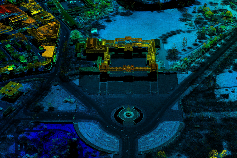
Buckingham Palace visualised using Environment Agency LIDAR point cloud data
The release of LIDAR point cloud data began in March 2016 and by the end of June the Environment Agency had made all 725 gigabytes of its point cloud archive, covering 175,000 square kilometres of England, available on DATA.GOV.UK
In January this year start-up Emu Analytics used Environment Agency LIDAR data in an interactive map enabling people to easily see heights of buildings across London and at the end of June released a similar map using these data showing building heights across the majority of England
Jonathan Smith, Head of Data Insight at Emu Analytics, said:
It is superb for start-ups like us that the Environment Agency is making its LIDAR point cloud available as open data. Point cloud data is a step up in terms of the level of detail we can achieve in modelling infrastructure and the natural environment. We are able to define the shapes of buildings and vegetation and even discover temporary infrastructure, such as cranes.
With the detail that point cloud provides we will be able to open up new use cases and offerings such as providing clutter data for line-of-site broadband companies or calculating the shadows nearby buildings would cast on a proposed array of solar panels.
In general the whole Open Defra ecosystem, within which point cloud sits, allows start-ups such as ourselves to easily work with the data, enrich it, and where possible, provide it back to the open data community.
Since the Environment Agency began releasing its LIDAR surveys as open data in September 2015 these data have found many surprising uses including helping archaeologists to discover ‘lost’ Roman roads and Minecraft enthusiasts to build virtual worlds.
With point cloud data users can create their own customised elevation models incorporating additional information about the type of ground feature (vegetation or hard surface) being surveyed, or the time the survey was conducted.
.png "Derby City Council Showcase")