Data standards: you can’t manage what you can’t describe
11 May 2026 11:45 AM
In 1928, a debate was held in the House of Lords on the right to dig up public roads (1). As one would expect, the debate was lively and articulate, however, two passages caught my eye in particular:
“Your Lordship: may have heard the humorous reply of the boy who defined a road as ‘a place to lay pipes in.’”
“The Minister of Transport, every half year, goes to the various highway authorities and asks them to give him the schemes of road maintenance and road repair to be undertaken during the half year. Those schemes are put together and co-ordinated and every effort is made to make the necessary repairs as little inconvenient to the public as possible.”
The tension between the rights of utility companies to access and maintain their apparatus, and the right of highway authorities to maintain safe and serviceable roads, is arguably one of the oldest and most persistent problems in British infrastructure. Over the course of nearly two centuries, many iterations of legislation have sought to oversee this tension (2). However, in the modern era, data standards have also played an increasingly pivotal role in how we now assess, describe, manage, and coordinate what takes place on the highway.

British Standard 7666 plays a fundamental role in how we respond to the increasing information demands that highly mobile, modern-day societies create and, in this blog, we’ll dig into why I believe this to be the case.
A need for structured information:
It was clear from the right to dig up public roads debate that pressures were arising from several areas, such as an increase in:
- street works activity
- traffic on the roads
- work costs due to the improved engineering standards of roads
- population density and human economic activity in general.
These trends are clear to see from the anecdotal accounts in the debate and many of the proposed solutions were legal or operational in nature.
However, although such solutions were certainly required, the need for high quality, standardised information about the structure of the highway, where it was, what it was used for, who used it, and what surrounded it was evident; although not explicitly stated.
This is clear from Lord Montagu of Beaulieu’s passage below:
“I have lately had an opportunity of gauging the state of London to-day. Between May 11 and May 14, within an area fairly close to this House, the road down to Millbank through Smith Square was torn up for a length of 500 yards and half the width of a very much used roadway was disturbed. In King's Road, Chelsea, between Walpole Street and Markham Square, the road was up for about 250 yards, leaving in places barely room for two vehicles to pass one another. King's Road, as your Lordships know, is a very much used highway, and is in a rather densely populated area. In Wellington Street the road was obstructed from Tavistock Street to the Strand for about 100 yards. I might go on almost indefinitely with these instances.”
This statement is packed with geospatial information, and in 2026, almost 100 years after the debate, we possess the high-quality data infrastructure that tracks all of it.
If Lord Montagu was around today, he’d most certainly be a fan of the National Streets Gazetteer (NSG), OS NGD Address and AddressBase, and the Department for Transport’s Street Manager system.
The NSG and Unique Street Reference Numbers (USRNs) would have been his starting point to identify the location and associated attributes of the streets he references. Using their USRNs, he would have used Street Manager to determine the nature of the works taking place and who was conducting them. Up next would have been NGD Address, allowing him to understand things such as the density of[CC1.1] properties linked to the streets via NGD Address’ Unique Property Reference Numbers (UPRNs).
However, although the above is possible now, authoritative data that is nationally consistent, and the national systems that are built around it, all require one key enabler.
Data Standards.
British Standard 7666:
You can’t manage what you can’t describe.
Lord Montagu could describe what he saw, but he could not describe the street as a data object — with a unique identity, a defined spatial extent, a relationship to its surroundings, and attributes that could be referenced and used in nationally scaled reporting systems.
First published in 1994 (the year I was born!), the BS7666 standard was developed to enable consistent recording and exchange of street and property data across local authorities and utilities. This standard became fundamental to implementing the New Roads and Street Works Act (1991), as the Act required authorities to maintain street gazetteers for coordinating works.
It is for this reason that it is recognised as one of core data standards on the UK Geospatial Data Standards Register (3).
In my view, BS7666 was precisely the answer to Lord Montagu’s conceptual blind spot. It doesn't just provide a way to name streets — it defines what a street is as a piece of structured information.
It gives it:
- a unique identifier (USRN) that exists independent of what anyone chooses to call it
- a defined geometry — where it starts, where it ends
- a place in a geographical hierarchy — locality, town, administrative area
- a status — is it adopted? Maintained at public expense? If so, by whom?
- a way to assign additional information – construction attributes, engineering attributes.
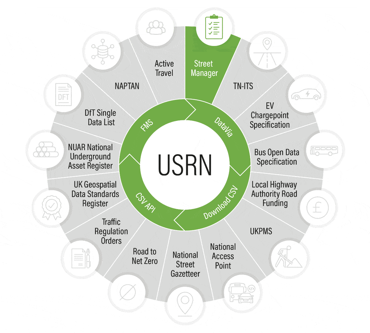
If BS7666 is the framework for conceptualising the street as a piece of structured information, then GeoPlace’s Data Transfer Format for the National Street Gazetteer is the logical representation of these concepts. It provides a formal structure, and instructions to physically implement and represent BS7666 in physical format such as a CSV file.
GeoPlace acts as a central aggregator for local authorities maintaining Local Street Gazetteers and makes available the consolidated National Streets Gazetteer to organisations such as the Department for Transport.
This data underpins the national permitting system Street Manager that manages the daily operations of street and road work permitting across England.
All of this is only possible because of the underlying data standards in place and mostly importantly the people, organisations, and relationships that sustain them.
Don’t forget the humans
In his book Why Information Grows (4), César Hidalgo argues that our ability to take what we’ve imagined in our minds and embody this into physical artefacts is what sets us apart as humans – for example books, songs, products, or even data standards.
The following quote from the book sums this up rather nicely:
“That's all the motorcycle is, a system of concepts worked out in steel. There's no part in it, no shape in it, that is not out of someone's mind” (Robert M. Pirsig)
But this is a process that takes time, energy, and above all, people and relationships. Structured information is a rare occurrence in the universe; as things often tend toward disorder. Creating structure from this tendency is hard. Maintaining and improving it is harder still.
In my view, this is precisely what data standards like BS7666 represent. They are not just technical specifications; they are the fruit of decades of collective effort to impose order on something inherently messy. Every USRN, every UPRN, every defined geometry, every maintained attribute in the NSG and NGD Address is a small victory against disorder.
However, pretty much none of this is achievable alone. Dense networks of people, working in the same problem space, physically or virtually, are what make national data infrastructure possible and most importantly sustainable. It is no coincidence that the National Underground Asset Register (NUAR) followed the same well-trodden path through its work on defining the Model for Underground Data Definition and Integration (MUDDI); agreeing on how to describe things before trying to manage them.
Data Standards are a shared language about the messy world surrounding us and it’s always important that we shout about how valuable they are; both the standards themselves, and the people behind them.
References
- House of Lords Debates, The Right to Dig Up Public Roads, 17 May 1928, Hansard: THE RIGHT TO DIG UP PUBLIC ROADS. (Hansard, 17 May 1928)
- Sunderland Gas Act 1857, and Public Utilities Street Works Act 1950 (repealed 1.1.1993), and New Roads and Street Works Act 1991
- UK Geospatial Data Standards Register – GOV.UK
- Hidalgo, C.A. (2015) Why Information Grows: The Evolution of Order, from Atoms to Economies. London: Allen Lane / Penguin.