How will the summer end: ‘bang’ or ‘whimper’?
15 Aug 2022 11:31 AM
The summer 2022 has been remarkable on many fronts, says Paul Davies Met Office Fellow (Meteorology).
We exceeded the 40°C threshold for the first time ever, and for England the January-July period has had 69% of average rainfall making it the ninth driest in a series from 1836, and the driest such period since 1976.
July was also the driest July for England since 1935 and the driest on record for East Anglia, southeast and southern England. Some locations, such as Odiham in Hampshire, have received little or no rain since 30th June.
What does this mean for the rest of summer and beyond? Is there anything we can glean from previous heatwaves or long-lasting periods of dry weather?
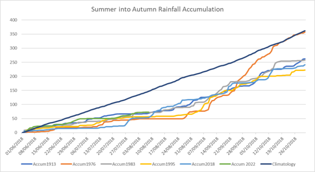
Below is a plot of rolling rainfall accumulation from 1 June to 31 October for the five driest summers on record (1913, 1976, 1983, 1995, 2018) compared to the average for the period 1991-2020. Meteorologists refer to this as the climatological average.
1976 and 1995 were notable for having a sharp transition to wet conditions in September, and to a slightly lesser extent 2018 in July and August. It is also noticeable how quickly rainfall recovered to average during early autumn 1976, and the preceding heavy rain and excessive flooding from mid-August.
Why do we see these sudden changes in weather patterns? To help us explain this we need to see the weather world through regimes. A regime is a persistent state of the atmospheric circulation which can be ascribed to a weather type, for example a regime may consist of a strong Atlantic Jet bringing a series of low-pressure systems, wind, and rain across the UK. Storms Dudley, Eunice, and Franklin were classic examples. Or it might be an area of high pressure leading to long periods of dry conditions and warmth.
In 1976, the regime pattern got stuck, with a persistent area of high pressure locked in across the UK for most of the summer. But then, remarkably, the regime abruptly changed within a few days to a more unsettled type with rain and thunderstorms. High pressure – with its associated heatwaves – has been the dominant regime affecting the UK during this summer, but what does the future hold as we transition into autumn.
To try to answer these and similar questions, the Met Office has been developing a tool, called Decider to identify and forecast regimes.
Decider is based on our ensemble system – which produces multiple forecasts with different starting points aiming to capture the ‘chaotic’ nature of the weather and express the answer as probabilities.
Using Decider, we can infer the regime type for this and the following week in the plot below. It suggests a change of regime next week from hot and dry associated with a high pressure regime (red colours) towards a pattern that is typically associated with low pressure (blue): less hot with a chance of showers and thunderstorms. The numbers in the boxes representing the probability and therefore reflecting the confidence in how one regime changes to another. So, what does that mean for the UK?

(Above) The output from the Met Office Decider system helps forecasters understand when a weather regime change is most likely to occur. The reds for high pressure are clearly most likely to give way to a regime dominated by low pressure into next week.
Based on today’s Decider forecast and medium-term forecasts, there is an increased chance of rain from early next week onwards. However, there is a question mark on duration, intensity and whether the wet pattern will continue into autumn.
For areas that have received none or very little summer rain, the question on what type of rain can we expect is important too. Especially as the Environment Agency has today confirmed drought status for eight of its 14 areas in England.
Will the rainfall suggested by the forecast be sufficient to shorten the duration of the drought? We will have to see, but the door is open to a forecast with more rainfall for southern England than we have seen since early June.
In the next seven days the forecast though has a lot more certainty. Providing the Met Office with sufficient confidence to issue thunderstorm warnings covering the greater part of the UK. The rain could be of sufficient intensity to result in high-velocity flows, flash flooding and debris as slow-moving thunderstorms deposit rain onto baked, hardened surfaces with water running off into potential downstream deluges.
This will it be a ‘hit-and-miss’ affair with locations only a few miles apart receiving no rain while others seeing extreme rainfall and flooding.
Before assessing the longer-range forecast into the rest of August and September, we may have to wait until the Atlantic Jet strengthens. This will be driven in part by the decaying remnants of hurricanes entering our latitude; driven in turn by an anticipated active hurricane season. At this range, indications remain mixed, highlighted in lower probabilities in the Decider plot above, but there are signs for further spells of wind and rain across the UK, especially across more northern and western areas with occasional incursions further south and east.
Back to the question: how will the summer end?
For some next week the summer will end with a ‘bang’ as intense thunderstorms are forecast for early next week, while others who miss the rain will perceive the change as a ‘whimper’.