KTN and UK Space Agency launch UK Space Sector Landscape Map
21 Jan 2021 03:59 PM
The new interactive tool is set to become a main point of reference for the UK space sector, mapping the capabilities of over 900 organisations in the industry.
Developed in collaboration with the UK Space Agency and with support from key stakeholders, the Knowledge Transfer Network (KTN) has outlined the universities, companies, funding bodies and networks that form the UK space sector.
The map is now available publicly through a free, interactive, web-based tool, allowing users to search and visualise the sector as never before. It will deliver high-quality insights and showcase our excellent space sector across the world.
Iain Hughes, Market Intelligence Manager, UK Space Agency yesterday said:
This tool will bring genuine value to stakeholders across the space sector and beyond. By providing access to new data, visualisations and search functions, it will generate insights that will help companies identify opportunities, improve their strategies for growth, and increase collaboration.
Andy Bennett, Knowledge Transfer Manager for Space at KTN yesterday said:
KTN supports innovative organisations by creating diverse connections to drive positive change. We have built landscape maps in many sectors in order to give a representation of current UK capabilities and activities which help identify and drive opportunities in innovation. This UK Space Sector Landscape Map showcases our knowledge and aims to support those both inside and outside the sector to build new collaborations. We hope that it supports our ambitious UK space sector to continue to grow and succeed.
The UK space sector is a huge economic success story, growing by over 60% since 2010. In addition, the sector supports wider UK economic activities worth an estimated £300 billion through the use of satellite services. This market is expected to grow further as government support unlocks commercial opportunities.
What does the map include?
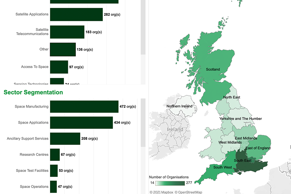
The map includes:
- over 340 space manufacturing businesses, from launch vehicle providers and satellite manufactures to component and materials suppliers
- over 300 satellite applications companies who deliver satellite communications services, process satellite data or develop applications dependent on GNSS or Earth observation data
- 44 space operation companies including launch services, launch brokerage services, proprietary satellite operation and ground segment operators
- 170 organisations offering ancillary services including consultants, IT and software services providers, insurers and legal services
- 67 research groups and universities across the UK with their research interests
- incubation centres, networks, funding opportunities, key sector organisations and developing spaceports
This tool will continue to improve and evolve over time, capturing the UK space sector as it grows. Companies and organisations belonging to the space sector not currently listed are invited to notify KTN for inclusion.
The interactive map allows users to search and filter by a range of data points including market segment, company details, technologies, expertise and capabilities. The satellite applications companies can be searched by the key markets they serve.
All featured organisations are also geographically tagged, allowing users to pan around the UK virtually, explore regions of interest, and to visualise the relationships between local space networks.
How can the UK Space Sector Landscape Map help?
The tool will offer value to all stakeholders interacting with the UK space sector by:
- identifying regional clusters of expertise to support local growth ambitions, signposting space support networks, and informing users’ strategies for investing around the UK
- supporting collaboration and innovation by providing a comprehensive and searchable directory of companies and organisations
- identifying UK capabilities, gaps, strengths, and opportunities to inform the development of the National Space Strategy and national space programmes
- informing market intelligence strategies, including the identification of potential collaborators or competitors within market segments, or new supply chains and customers
- signposting of public and private space-focused funding bodies
- provision of a knowledge base to inform analysis among the UK space community and sector researchers
- raising profiles of UK space organisations of all types and sizes, providing a free platform to promote expertise and capabilities and inform a range of stakeholders
The map can be accessed here.
Brexit
Check how the new Brexit rules affect you