Will Hurricane Ida affect the UK’s weather?
6 Sep 2021 12:50 PM
Hurricane Ida has seen winds of up to 150mph and intense rainfall bringing widespread flash flooding to a swathe of America, in what has been the fifth strongest storm to hit the US mainland.
Ida formed over the Caribbean Sea at the end of August, and then moved north westwards becoming a tropical storm. As Ida moved over the Gulf of Mexico it tracked across a deep area of warm water and developed rapidly into a Category 4 Hurricane and made landfall over Louisiana last Sunday evening, UK time. After making landfall Ida started to lose her strength; like all hurricanes, she drew her energy from warm seas. However, although Ida’s winds quickly eased, she has (as forecast) continued to bring a trail of extreme rainfall to the north-eastern United States, notably New York. The heavy rainfall lasts longer and can affect more people than the damaging winds do.
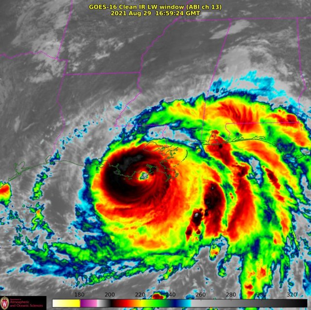
Hurricane Ida has been the fifth strongest hurricane to make landfall on the mainland of the United States.
Impacts in the US from Ida have been severe, with reports of at least three inches of rain falling in New York’s Central Park within an hour and Louisiana seeing similarly devastating conditions earlier in the week. One million are reported to be without power, and sadly there have been a high number of fatalities.
Met Office Expert Operational Meteorologist Chris Almond, said: “The sheer amount of rainfall within this warm tropical air saw fairly widespread totals of 150 to 250 millimeters, which fell over a couple of days, and is quite exceptional in itself. But Central Park in New York actually recorded 80 millimeters in just one hour, which is a phenomenal amount of rain. That’s nearly over a month’s worth of rainfall in just an hour, and almost double the previous record, which was around 50 millimeters in an hour: and that was only set earlier in August. It has been an exceptional spell of weather for parts of the southern and eastern parts of the United States.”
While Ida’s affects are still being felt across America, bringing a deluge of rain and continued strong winds, some are now wondering if Ida will travel across the Atlantic and impact on the UK’s weather.
In short, no, not directly. But, as is often the case in the North Atlantic hurricane season, the set up in North America can have an influence on the dominant weather we’re likely to see in the UK because of the effects it can have on the jet stream, which straddles the Atlantic and drives a lot of the UK’s weather.
In recent days, the UK has been under the influence of a high-pressure system (a ‘blocking high’ set up). This has seen largely benign weather over the UK, with relatively dry conditions, along with spells of sunshine, but more prolonged cloud for some.
According to Met Office models, Ida is set to break up when it enters the Atlantic and is very unlikely to travel across the ocean intact. However, it will have an influence on the position and strength of the jet stream across the Atlantic – currently the jet stream is very weak, but it will strengthen as the remnants of Ida move northeast away from North America. The strength of the jet stream can be determined by the temperatures on either side of the flow, with cool air to the north and warm air to the south. When the temperature contrast is greater, such as now with Ida bringing a lot of warm air to the south, the jet becomes more energised. The direction the jet stream then takes will help determine weather patterns for the UK this weekend, with a more northerly position helping to hold high pressure close to the UK.
Met Office Expert Operational Meteorologist David Oliver recently said:
“Ida has obviously had some significant impacts in the US, but that weather system is not expected to travel across the Atlantic and reach the UK as an active system.
“However, it is common for the hurricane season in North America to play a factor in the weather patterns affecting the UK, and in most cases that’s down to its role in shifting the upper air that drives our weather systems.
“Hurricanes have a major impact on the transport of heat and moisture from the tropics into the North Atlantic.”
David added:
“As Ida breaks up, the low-pressure system and warm tropical air associated with it will help to accelerate and shift the jet stream over the Atlantic. The behaviour of the jet stream is complex but overall it will tend to lie to the north of the UK, this helping to hold high pressure close by. So, whilst rain is likely to spread to some northern parts of the UK on Sunday and into Monday, for many places conditions will remain dry and increasingly warm this weekend and into the first half of next week.”
A shift toward more widely unsettled weather isn’t currently expected until later next week as the high pressure finally gets unseated from its current position close to the UK.
Check the latest Met Office forecast on the Met Office website, app or on social media.