

Met Office
|
|
Our changing weather patterns: a tale of abrupt transitions
Our weather is notoriously changeable – that is partly what makes it one of the nation’s talking points. But peering through the statistics a striking pattern emerges: one where the weather oscillates abruptly between different and contrasting phases lasting for a while before the next phase in the sequence begins to dominate.
Let’s look at January’s conditions: the average across the month isn’t headline grabbing. But the pattern back-and-forth between weather types is remarkable.

The year began warm, but within the first five days it had transitioned to a notably cold and dry period. But then, after a further couple of weeks, it transitioned again to a mild and wet spell.
Tapping into warmth
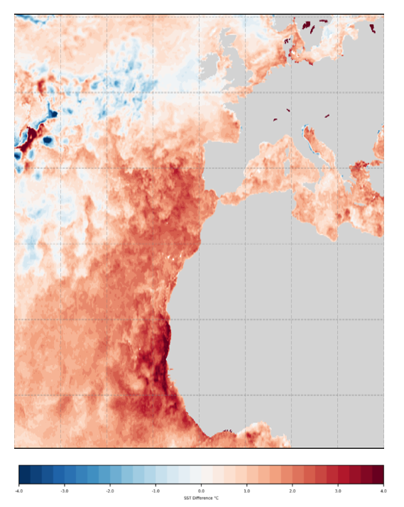
Sea-surface temperature anomalies from the latest OSTIA analysis, 01 February 2024, compared to the European Space Agency Sea Surface Temperature Climate Change Initiative (ESA SST CCI) climatology data. Indicative of the source region for southern UK coming from the maritime heatwave west of NW France and Portugal.
February may turn out to be remarkable on many fronts. Exceptionally mild and wet across a broad swathe of the UK in the first week, with a major change from the end of this week and beyond as very cold air from Scandinavia floods south into the UK.
We can project these extremes onto large-scale weather patterns: with high pressure towards Greenland; low pressure over Scandinavia; and low pressure occasionally stretching across the UK and into continental Europe. This pattern is characteristically described as a block; when the atmosphere gets ‘stuck’ for long periods of time.
Paul Davies is the Met Office’s Principal Meteorologist. He said: “Against this backdrop, the tropical Atlantic is very warm. Sea temperatures off the north-west African coast are currently comparable to values more typical for July.
Winds will continue to tap into this area of warmth, briefly drawing modified air north into southern and western parts of UK. This tropical-sourced air is being forced to rise as it comes up against the blocked pattern and over western hills bringing persistent, locally heavy rain here, and as the air descends to the lee side of these hills it has been introducing very mild and gusty conditions; because of the foehn effect.” This effect – which occurs where air crossing mountains is warmer and drier on the lee side – was also responsible for the record-breaking January temperature in NW Scotland. The weather station at Achfary recorded 19.9°C on 28 January: a new UK daily maximum temperature for January; and a new winter record for Scotland.
Colder conditions ahead
Paul Davies continued:
“Then comes the expected change in weather, with winds switching north and drawing very cold air from the Arctic, initially arriving across Scotland, Northern Ireland and Northern England later this week and then heading further south into southern England. This may mean a significant contrast between the recent weekend, and next weekend with spring-like conditions one weekend and the potential for wintry hazards, especially in those regions susceptible to east and northeasterly winds across northern parts of the UK next weekend.”

Temperature anomalies from the latest GloSea forecasts for the week commencing 12 February. It shows cold air over the UK and deep cold residing over Scandinavia. GloSea is the seasonal prediction system developed and run operationally at the Met Office.
The forecasters’ challenges will be to determine:
- the exact arrival time of the cold conditions;
- and the associated battleground between the cold air in the north, and the mild in the south. This will create a zone of disruptive weather, including heavy rain, snow and ice.
At this stage it’s too early to predict with any confidence the evolving story. But if the boundary pivots and stalls, it could result in snow and blizzards for some. If the cold air digs south more quickly, frost and ice may be the hazards to watch out for; while if the cold air is restricted to the north, the hazards may be rain and strong winds in the south, with snow confined to Scotland, Northern Ireland and Northern England.
Phil Stocker is the chief executive of the National Sheep Association. He yesterday said: “The late winter and early spring period can be an extremely concerning time for livestock farmers, particularly those working in the UK’s more exposed and upland areas. Any cold snap, especially if accompanied by significant snowfall, can bring notable hardship to livestock, and of course hill farmers.
“I find it helpful that the Met office is doing more to warn of the risk of bad weather conditions – it gives farmers the chance to assess the risks and do what they can to prepare.”
Paul Davies added: “It’s a close call with only minor wobbles in the weather patterns changing the course of the evolution and associated impact to the UK.”
Through to early March, there is increasing chance of sleet or snow, especially in the north and east of the UK with greater than normal potential for disruptive snow. The specific locations wintry hazards will become clearer as the lead time decreases.
Our advice therefore is to keep abreast with the latest forecasts and warnings.
Original article link: https://blog.metoffice.gov.uk/2024/02/05/our-changing-weather-patterns-a-tale-of-abrupt-transitions/
